GonnaLand Beta FAQ
Contents
- Getting started: What do I need? · Where do I mount it? · Aircraft profile
- Flying with it: What do I do in the cockpit? · What will I hear? · Callouts cut off · Reading the display · Overheating
- How it works: The short explanation
- Safety: Advisory only
- Your data: The debrief · Why share? · What leaves your device · ADS-B receivers
- Beta: Known gaps · Sending feedback
What do I need?
An iPhone or iPad running iOS 16 or later, and a suction mount, like this one. That's the whole install, no panel integration, no wiring, no box in your avionics stack, and no data connection in flight. Everything runs on the device.
During the beta the app comes through Apple's TestFlight. You should have received an e-mail from Apple inviting you to install GonnaLand from TestFlight; if you can't find it, check your spam folder. Install TestFlight from the App Store first if you don't have it, then open the invitation on your phone.
Where do I mount it, and how?
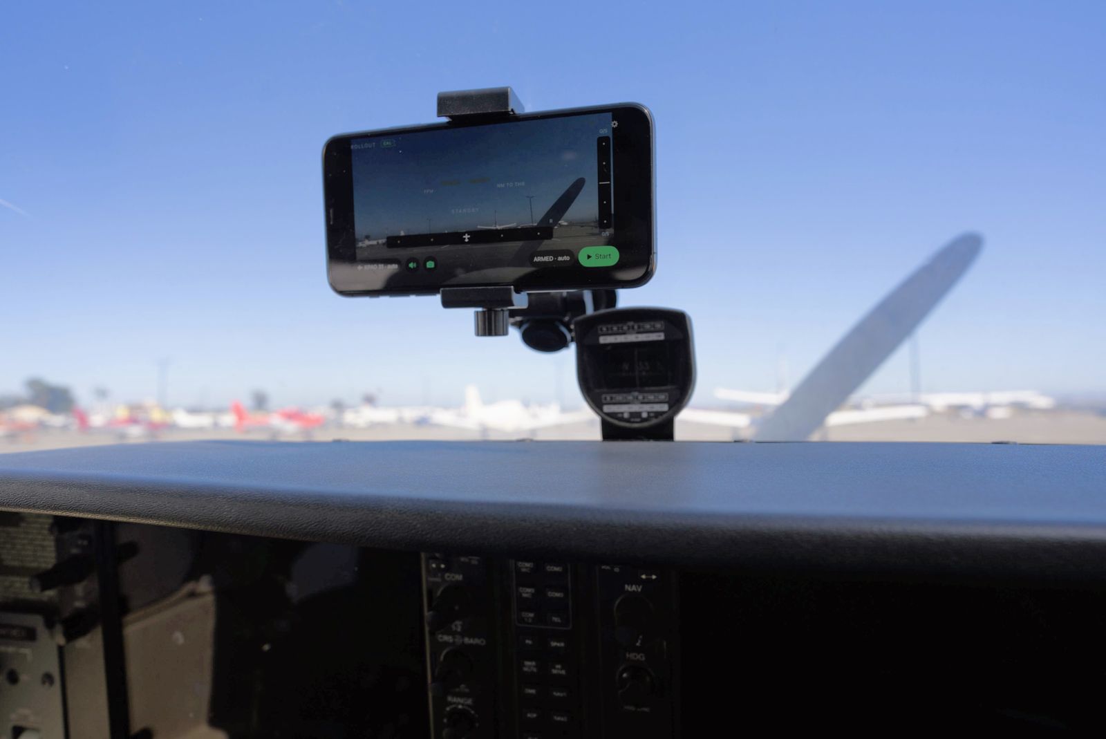
On the windshield or glareshield, with the rear camera looking forward down the runway. A suction mount works well; what matters is that it holds the same position reliably. Landscape is preferred. Portrait works, but it roughly halves the horizontal field of view.
The home screen is the viewfinder. It shows exactly the frame the app records. Check it on the ground before you go. The app needs to see the whole runway, all four corners, to measure where you are relative to it. Minimize obstructions like the cowling, compass etc.
Once mounted, do not change the mount. This would invalidate the camera calibration and may result in inaccurate readings.
Aircraft profile
The picker in the setup flow seeds a Cessna 172, 152 and 182, a Piper PA-28, a Diamond DA40, a Cirrus SR22, and "Other / custom". These are starting points for the mount geometry and approach speed. Pick the closest.
If your aircraft is not in the list, or you have some extra time, you can measure each parameter yourself. Settings (tap the gear icon at the top right) → Aircraft & mount. Measure with a tape:
- Lens height above ground
- Lens forward of the main wheels
- Lens off the aircraft centerline (left or right; leave 0 for a mount centred on the windscreen)
These are what turn a camera measurement into your wheels. Without them the app would be telling you how high the phone is, which is not the number you care about in the flare.
What do I actually do in the cockpit?
Nothing. Open the app and fly.
Arm automatically is on by default, so the app watches for approaches on its own, picks the runway you're approaching from the FAA database, and starts and stops recording without being asked. You don't need to arm between circuits, and there's no button to find on short final. If a recording turns out not to have been an approach at all, it's discarded rather than left on your phone.
You can still take over: Start now forces a recording anywhere, and a manually started one is never auto-discarded.
What will I hear, and how do I hear it?
Pair your headset with the phone over Bluetooth, the same way you would to listen to music. That's what puts the callouts in your ears rather than out of the phone's speaker, where you will never hear them over an engine. If your audio panel has a Bluetooth input, pairing to that works too and puts the callouts on the intercom for everyone aboard.
Then, on approach, you'll hear height callouts five hundred, two hundred, one hundred, fifty, forty, thirty, twenty, ten, and then a countdown through five, four, three, two, one, plus "guidance degraded" if the app loses confidence during an approach.
Two things worth knowing. The heights are your wheels above the runway, not the camera and not the altimeter. And callouts only arm after you've been above 500 ft AGL on the approach. So a low circuit that never climbs through 500 ft gets none, by design: it keeps taxi, takeoff and low pattern work silent.
The countdown will not happen on every landing, and that is deliberate. Those last few feet are called only when the app's precision is good enough to stand behind them; when it isn't, it stays quiet rather than counting you down on a number it doesn't trust. Not hearing the countdown every time is not a fault.
My callouts got cut off, or didn't play at all
Almost always the headset. Most ANR headsets mute or duck auxiliary audio while the radio or intercom is live, so a callout that lands during a transmission is simply lost. The app has no way to detect this, and no way to work around it.
The fix is in the headset, not the app:
- Bose A20 and A30: set the audio switch on the control module to the "Mix" position. In "Mute" it silences auxiliary audio whenever there's radio or intercom activity, which is exactly what swallows a callout on short final.
- Lightspeed and others: look for an audio-priority, "ComPriority" or auto-mute setting and set auxiliary audio to mix rather than mute.
Also worth checking: the speaker icon on the app's home screen is on, the phone isn't muted or on silent, and it's actually connected to the headset rather than another Bluetooth device it found first.
What does the display mean?
The big number is wheel height above the runway. Around it: sink rate, distance to the threshold, a centerline needle, and a glide-slope diamond referenced to that runway's published glide path rather than a generic three degrees. Both needles are fly-to. Centre them the way you would an ILS.
The word in the top bar is how much the app trusts itself:
- FULL (green): the camera has the runway and everything agrees.
- DEGRADED (amber): still usable, but impaired; usually the camera has lost the runway and it's running on GPS and barometer. Everything turns amber.
- MUTED: dashes instead of numbers, and the needles disappear. When the app can't stand behind a number it shows nothing rather than guessing. Treat dashes as information, not a fault.
Will my phone overheat?
A phone on a glareshield in direct sun, running the camera and neural engine, is genuinely a hard thermal case, and we'd rather tell you what happens than pretend it doesn't.
As the device warms, the app sheds work in stages instead of dying: it slows down the vision processing first, keeping the display and callouts. If it reaches the hottest stage it drops vision entirely, blanks the screen to shed heat, and tells you plainly "device hot · display suspended, callouts continue". Video keeps recording throughout, and the callouts keep coming from the barometer and motion sensors.
Practically: give it some shade when you can, let it cool between approaches if it feels hot, and don't leave it baking on the glareshield during a long ground stop. iOS itself will take the camera away if the device gets hot enough, which no app can override.
How does it work?
The camera watches the runway. On-device computer vision finds it in each frame and works out where you are relative to it. How high, how far, and how far off the centerline. That's fused with GPS, the barometer and the phone's motion sensors, so the guidance holds together when any one of them is having a bad moment.
The camera is what makes it precise. GPS and a barometer can tell you roughly how high you are; neither is remotely good enough to call your wheels in the last hundred feet. Seeing the runway is what turns that into a number worth listening to on short final, and it is the part we keep working on.
The runway itself comes from the FAA's national database, which is also where the published glide path comes from. So the diamond reflects the approach that runway actually has, not an assumed three degrees.
All of it runs on the phone. Nothing is sent anywhere to make it work, and it needs no connection in flight.
The reason it can be precise about your wheels is the boring part: the measurements you enter. The camera measures the camera; the geometry does the rest.
Is this certified? Can I use it to descend?
No, and no. These are the terms you accepted at first launch, and they are not softened here:
- Not certified equipment. GonnaLand is not a radar altimeter, GPWS/TAWS, or VGSI, and is not a substitute for any equipment required by regulation, nor for looking outside. Never rely on it for navigation.
- Not a basis for descent. Descent below any DA/DH or MDA requires the visual references of 14 CFR 91.175(c), seen by you out the window. GonnaLand does not identify those references and must never be used as a basis for descending below minimums.
- Pilot in command. You retain full responsibility for the safe conduct of the flight under 14 CFR 91.3. Use of GonnaLand is at your sole risk.
- Provided as is. Accuracy is not guaranteed and degrades in poor visibility, on unmarked runways, and during the flare.
It is a training and situational-awareness aid. The most useful thing it does is help you notice a destabilized approach earlier, and then you fly the aeroplane.
How does the debrief work?
On the phone, open any recording (Settings → Recordings) and play it back with the display alive. And if "Sharing" is on, sign in at app.gonnaland.com with the same account you use in the app. Your approaches are there to replay, video alongside the HUD, the needles and the callouts, plus the flown track and a height profile you can scrub through.
It is the same picture in both places, which is the point: you can sit down with a student or an instructor afterwards and look at the approach together, rather than trying to remember what it felt like.
Why would I share my approaches?
We started this because landing well is the hardest thing we teach and the least instrumented. If you want it to be good for the next student in the left seat, sharing approaches is the single most useful thing you can do.
GonnaLand recognises runways because it was trained to. Every shared approach becomes training and evaluation data for that recognition, and the thing that limits it today is not cleverness, it's variety. Runways we've never seen. Lighting we've never flown in. Aircraft we don't own, mounted in positions we didn't think of. Grass strips, displaced thresholds, faded paint, low sun, haze.
The same flywheel is how we plan to teach it to see traffic. With a compatible ADS-B receiver connected, the app may capture a few camera stills when the receiver reports an aircraft that might be in view. Each report is ground truth that says "there is an aircraft near this frame", which is exactly how the runway detector was built. Stills only, a few megabytes per flight; never continuous video of your cruise.
It's on by default, and you can turn it off at any time in Settings → Recordings → Share approaches. Turning it off stops uploads immediately.
What exactly leaves my device, and what never does?
When sharing is on:
- The approach video and sensor log
- Runway identifier, approach duration, aircraft name
- Device model and app version
- An anonymous account identifier; your name and email stay in your GonnaLand account and are never attached to a recording
- With a compatible ADS-B receiver connected, possibly brief bursts of camera stills captured when the receiver reports nearby traffic, with the reports themselves
What never leaves:
- Recordings that fail the quality bar, simulator and desk tests, no runway, no GPS, or too short to be a real approach
- Anything at all while sharing is off; turning it off stops uploads immediately
- Anything over cellular, uploads run only on Wi-Fi, and only while the app is open and not recording
The app uses the microphone only when you ask it to: Record cockpit audio (off by default) records cockpit sound with your approaches, and the headset delay check listens to its test sounds on the phone without saving them. Public links never have sound.
Should I connect my ADS-B receiver?
Yes, if it broadcasts standard GDL90 over Wi-Fi. Stratux, SkyEcho 2 and Stratus all do. Join the receiver's network and the app finds it automatically. Sentry and Garmin receivers are not supported. They're locked to their manufacturers' own apps.
What it gets you is a better position source. Aviation receivers use WAAS-corrected GNSS with an antenna that has a clear view of the sky; a phone has neither, and is noticeably weaker vertically in particular. GonnaLand knows this and trusts a receiver's fixes considerably more than the phone's when both are available.
On a Wi-Fi-only iPad it is the difference between working and not working at all, because those have no GPS whatsoever. On an iPhone or a cellular iPad it is a genuine improvement rather than a necessity. Most useful early, before the camera has picked up the runway, and any time the camera can't see it. Once vision has the runway on short final, the camera is doing the precise work and the GPS matters much less.
What doesn't work yet?
It's a closed beta, and this is where it stands:
- Day VMC, runway visible. The camera has to be able to see the runway. Night, low visibility, and heavy precipitation are not what this is for yet.
- A small flight-test campaign. The accuracy we've measured comes from a handful of instrumented flights at a few Bay Area airports. Your airport is probably not one of them, which is exactly why shared approaches matter.
- Wi-Fi-only iPads have no GPS. On those, nothing auto-arms and nothing can be shared, unless you connect a supported ADS-B receiver. The app now flags this during setup on any iPad, but it can't tell which iPad you have, only you know whether yours has cellular.
How do I report a problem or send feedback?
The beta has a discussion group: GonnaLand beta group. Post there first. Other testers may be seeing the same thing, and answers there help everyone. You can also email hello@betterself.ai. We read everything, and in a beta this small you'll get a real answer.
The most useful thing you can include is which approach: the airport, the runway, and roughly when. If sharing is on and the recording uploaded, that lets us replay exactly what you saw, frame for frame, and see the problem rather than imagine it. "The callouts sounded late at KXYZ on Tuesday afternoon" is worth more than a page of description.
GonnaLand is an advisory training aid, not certified equipment. See the Terms of Service and Privacy Policy. Betterself.ai LLC · hello@betterself.ai